The Quadrangle is named 'Beverly Hills Quadrangle', and is part of the California - Los Angeles County Sector.
2. The Adjacent quadrangles are:
Canoga Park; Van Nuys; Burbank;
Topanga; Hollywood;
Venice and Inglewood.
3.The Quadrangle was first created in 1995.
4. It has been used the NGV Datum 1929 (National Geodetic Vertical Datum 1929).
5. The Scale used is a typical Large Scale for Topographic Maps: 1:24,000.
6.
a- At the Above Scale, 5 meters are equal to 1,200 meters on the ground/real world.
b- 1.893342 Miles (5*24,000/63360)
c- One Mile on the Ground is equal to 2.64 Inches.
d- 3 Kilometres on the ground is equal to 12.5 centimeters on the USGS map.
7.
The Contour line is 20 feet on the USGS map.
8.
a) The Public Affairs Building is located at 34 04'28"N, 118 26'20"W under Degree/minutes/seconds system
and 34.0713 N, 118.4366 under decimal degrees system.
b) The Santa Monica Pier Tip is located at 34 00'27"N, 118 30'00"W under Degree/minutes/seconds system
and 34.0045N 118.5W under decimal degrees system.
c) The Upper Franklin Canyon Reservoir is located at 34 37'12"N, 118 24'36"W under Degree/minutes/seconds systemand 34.6187N, 118.406W under decimal degrees system.
9. What is the approximate elevation in both feet and meters of:
a) Greystone Mansion (in Greystone Park) --> It is approximately 600 feet (about 183 meters);
b) Woodlawn Cemetery --> It is approximately 120 feet (36.6 meters).
c) Crestwood Hills Park --> It is about 800 feet (244 meters).* contour lines are very close because the topography is steep, it is not possible to figure out a precise line in that area.
10. What is the UTM zone of the map?
It is 11S
11. What are the UTM coordinates for the lower left corner of your map?
3763000North (from Equator) 361000 East (from Westernmost point in the Quadrant)
12. How many square meters are contained within each cell (square) of the UTM gridlines?
1,000,000 square meters
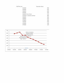
13. Obtain elevation measurements, from west to east along the UTM northing 3771000, where the eastings of the UTM grid intersect the northing. Create an elevation profile using these measurements in Excel (hint: create a line chart). Figure out how to label the elevation values to the two measurements on campus. Insert your elevation profile as a graphic in your blog.

14. What is the magnetic declination of the map?
14 deg. East
15. In which direction does water flow in the intermittent stream between the 405 freeway and Stone Canyon
Reservoir?
Approximately from North to South
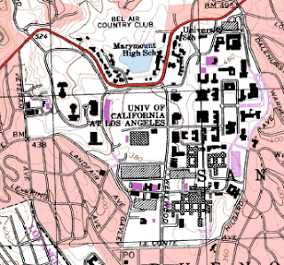
16. Crop out (i.e., cut and paste) UCLA from the map and include it as a graphic on your blog.

ANSWERS
ReplyDelete