MAP 1
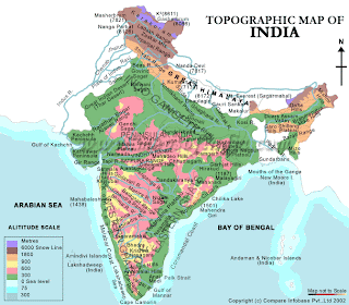 This Map, which contains physical feautures, is a clear example of involvement of locational processes, Toponymy science (or art?). However, probably because at the origin was very well contextualized by the information provided by the original web site, it misses an absolute localization such a description of its geographic coordinates.
It is not certainly a mental map due to the number and the precision of elements contained and the lines/boundaries' high definition. Thanks to the title above, we can assume that we are talking about the subcontinent India which pretty much is located on a certain area of the world (Asia). The intent of the publisher probably wasn't locating India but describing the composition and the features of its surface. In order to do this, a scientifically precise elevation scale has been necessary and it has been chosen the mean sea level (which is calculated on the International ellipsoid and I assume it has been used to referenciate also this map even if I am not sure..).
This kind of maps is clearly used to show HOW THINGS ARE and not how they look like to us. There are not human landmarks or items/objects we could see if we were walking on that area, they are not necessary. Also political Boundaries are deliberately not marked, they are just inferred from the colors of mapped physical areas. Colors in Physical maps represent different layers/characteristics of the surface, and generally, like in here, are similar to the color of objects in the real world. For example the mountains are rocky and poor in vegetation, while plans and rivers' basins are covered by lot of vegetation then are green. At a small scale of representation like on this map, the clearance is important to do not confuse people and I find this a very good strategy to communicate and separate important things from not relevant and to provide a more clear and efficient "look" for the attributes showed by the map.
MAP 2
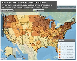
This is map which states other kind of information: a human related fact. In this case, boundaries have been necessary in order to show a data trend. If the map we were using was going to be the same than the first one, there was no information displayed as the distribution of a pattern can only be shown in relationships and differences between areas, adjacent or not. the main point is the exaltation of differences, and for this reason, the map could be considered a rationally-elaborated Mental Map of the problem, in this case Diabetes in the U.S.
A geographically perfect dimensional scale is used to show every group of counties in every state.
However I personally do not agree with the author, because this work could have been done much better: being a human related issue, it makes much more sense to describe the entity of population involved. For this reason, I would have personally related the area of every county to its amount of resident population, rather than its topographical surface area... it is not the distance and the scale of every group of counties to be important but the amount of population involved. I like the strategy to show other, non relevant countries with physical attributes exclusively, because it allows to focus better and immediately to the object to be mapped.
MAP 3
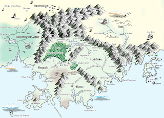
The Third map is from a fantasy game. Being contextualized into a game of a primitive era, the Author intended to maintain precise but approximate boundaries for both physical and coastline features.
Mountains, Trees and Human buildings are iconically represented, in a way that allows the reader to understand the main characteristics of each place in order to create certain sensations and behaves, through associations with particular aspects such as the possible dangers of a forest area or mountains. This is typical of Mental Maps, to which belongs this one. Colors are used to help the recognizance of features, as well as suggestive names. The Features illustrated are exclusively those necessary for the adventure/game, and does not consider many other information such as scale, exact distances . The kind of geographic question is in this case the Association with facts and events that occur/might occur within certain areas/objects/features. The use we do of this typology of maps is to understand, relate to and navigate the environment/area.

 This Map, which contains physical feautures, is a clear example of involvement of locational processes, Toponymy science (or art?). However, probably because at the origin was very well contextualized by the information provided by the original web site, it misses an absolute localization such a description of its geographic coordinates.
It is not certainly a mental map due to the number and the precision of elements contained and the lines/boundaries' high definition. Thanks to the title above, we can assume that we are talking about the subcontinent India which pretty much is located on a certain area of the world (Asia). The intent of the publisher probably wasn't locating India but describing the composition and the features of its surface. In order to do this, a scientifically precise elevation scale has been necessary and it has been chosen the mean sea level (which is calculated on the International ellipsoid and I assume it has been used to referenciate also this map even if I am not sure..).
This kind of maps is clearly used to show HOW THINGS ARE and not how they look like to us. There are not human landmarks or items/objects we could see if we were walking on that area, they are not necessary. Also political Boundaries are deliberately not marked, they are just inferred from the colors of mapped physical areas. Colors in Physical maps represent different layers/characteristics of the surface, and generally, like in here, are similar to the color of objects in the real world. For example the mountains are rocky and poor in vegetation, while plans and rivers' basins are covered by lot of vegetation then are green. At a small scale of representation like on this map, the clearance is important to do not confuse people and I find this a very good strategy to communicate and separate important things from not relevant and to provide a more clear and efficient "look" for the attributes showed by the map.
MAP 2

This is map which states other kind of information: a human related fact. In this case, boundaries have been necessary in order to show a data trend. If the map we were using was going to be the same than the first one, there was no information displayed as the distribution of a pattern can only be shown in relationships and differences between areas, adjacent or not. the main point is the exaltation of differences, and for this reason, the map could be considered a rationally-elaborated Mental Map of the problem, in this case Diabetes in the U.S.
A geographically perfect dimensional scale is used to show every group of counties in every state.
However I personally do not agree with the author, because this work could have been done much better: being a human related issue, it makes much more sense to describe the entity of population involved. For this reason, I would have personally related the area of every county to its amount of resident population, rather than its topographical surface area... it is not the distance and the scale of every group of counties to be important but the amount of population involved. I like the strategy to show other, non relevant countries with physical attributes exclusively, because it allows to focus better and immediately to the object to be mapped.

MAP 3
The Third map is from a fantasy game. Being contextualized into a game of a primitive era, the Author intended to maintain precise but approximate boundaries for both physical and coastline features.
Mountains, Trees and Human buildings are iconically represented, in a way that allows the reader to understand the main characteristics of each place in order to create certain sensations and behaves, through associations with particular aspects such as the possible dangers of a forest area or mountains. This is typical of Mental Maps, to which belongs this one. Colors are used to help the recognizance of features, as well as suggestive names. The Features illustrated are exclusively those necessary for the adventure/game, and does not consider many other information such as scale, exact distances . The kind of geographic question is in this case the Association with facts and events that occur/might occur within certain areas/objects/features. The use we do of this typology of maps is to understand, relate to and navigate the environment/area.


No comments:
Post a Comment