The STATION FIRE of 2009 in Los Angeles County
INTRODUCTION
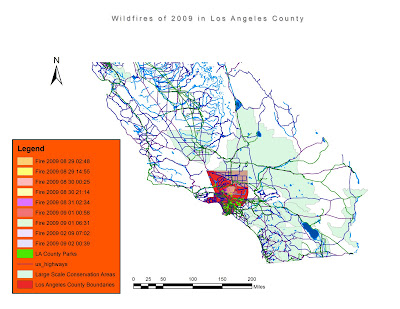
The Angeles National Forest (ANF) is a mountainous habitat that is situated in the San Gabriel Mountains north of Los Angeles County. In August 2009, Station Fires decimated over 160,577 acres (655 square kilometers) of this territory.The Station Fire was one of the largest fires in the history of LA county. As shown in the first of the four maps (which shows LA County in the context of Southern California), we can see that the fire took up entirely into its boundaries. To have a comparison of the size, 1 County's square kilometer every 19 has been burned by fires (655 on 12,308 km2, according to Wikipedia).
BODY

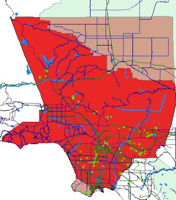
The map below displays natural features, such as river, streams and the topography within the neighborhoods of the Fires, the boundaries of Los Angeles County and the most important Conservation Areas and National Park (green/light red)
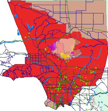
The fires started downhill, in a point of the Fire's perimeter relatively close to populated areas and traffic axis (see third and fourth map) , and spread in N direction over the parkland.


As we can see in the fourth and fifth maps, one factor why the station fire spread so quickly and why it was so hard to stop is likely to have been the scarce sources of water and waterlines within the fire perimeter, as well as capillary roads' distribution within the area. This means that firefighters were not able to hook up their hoses and fight the fires frequently and directly, they had to set controlled fires to and shovel dirt in order to counter the fire, while certain areas where fire was growing were simply inaccessible to firemen.
Also, Rivers, Streams and Lakes act as barriers for fires, which in this case may have had no obstacles along its way, sprawling in every direction and making efforts for firemen harder.
In fact, as we can see from the perimeters, the fire sprawled everywhere in the forest following elevation. The only sources of water or other fire fighting techniques they could use to slow down the fire was to use helicopters which were in limited number. Overall, there are 137 kilometers of water lines within the station fire perimeter, much less than the average of the rest of LA County.
Fire, as shown in the Second and the following fifth map, went fast in the initial phase when was climbing hills of ANF, and only in a second moment burned the largest section homogeneously toward E-NE, supported by the global winds coming from the Ocean.

Fires often run uphill on these slopes and even animals find it difficult to outrun a fire that moves uphill 16 times faster than it moves on flat land. (Sahagun, 2009).
The distinctive topography of the Angeles National Forest is one of the main reasons for the destruction and speed of the Station Fire. Reports from the incident stated that Fire was so large and powerful that only moderate rainfalls and the onset of winter conditions assisted the firefighters in controlling the fire. The potential for mudslides also is another effect of this natural disaster (Topynka-Lyn 2009).
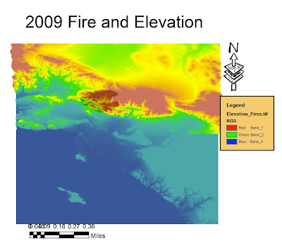
The burnt area varies in slope and aspect, but overall it goes from lower to higher elevations, and from South West to North East, partially following the winds or breezes coming from the ocean but mostly a slope uphill.
The above map (5th), is a bidimensional representation of elevation in the area (DEM). The Black Shadow visible in the Red Area (Mountainous Area), is the extension of the Station Fire.
It shows how the Station Fire, after starting just at the feet of those mountains, sprawled north following the steep hills.
GIS analysis can predict where these conditions are likely to occur again in future, and which populated areas could be more affected by debris, erosion and mudslides caused by the fires, by analysis of Topographic features and Digital Elevation Models.
CONCLUSIONS
Overall, GIS analysis allows better studying, treatment and prevention of fires, as they have a very strong spatial component. In particular, allow us understanding processes such as those described below, which have been crucial during the event of the Station Fire in Los Angeles:
- Fires are more likely to occur for human actions, in fact are very related with presence of population (Risling, 2009).
- Elevation and Topography of land play a primary role for SPEED, EXTENSION AREA, ORIENTATION of fire's Sprawl, as warmer air tends to run uphill in higher elevations and also winds that could support fire are stronger the higher the elevation.
- Presence of Natural Barriers such as Waterbodies, Walls, Artificial Cutting edges or Roads are extremely important as factors for the control of fire.
Also, Roads are useful as Transportation way for Firemen and for capillary actions in all needed points of intervention.
REFERENCES
- “2009 California Wildfires.” Wikipedia, the Free Encyclopedia. Visited 19th November 2010.
- Bloomekatz, Ari B. “Station fire is largest in L.A. County’s modern history.” LA Times. 2nd September 2009. Visited 22nd November 2010.
- “Los Angeles County Spatial Information Library.” Department of Public Works. http://gis.dpw.lacounty.gov/oia/index.cfm?agree=agree
Visited on 21st November 2010.
- Risling, Greg. (September 2, 2009). "Huge wildfire portends bad Calif. fire season". Washington Post. Associated Press. http://www.washingtonpost.com/wp-dyn/content/article/2009/09/01/AR2009090100224.html?hpid=moreheadlines. Retrieved September 3rd 2009, visited 23rd November 2010.
- Sahagun, Louis. “Angeles National Forest Fire Takes Toll on Wildlife.” 1 Sept. 2009.
http://latimesblogs.latimes.com/greenspace/2009/09/fire-environment.html
Visited 23rd November 2010.
No comments:
Post a Comment