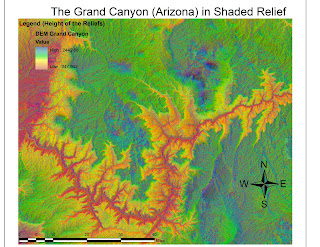
THE GRAND CANYON - ELEVATION DIGITAL MODEL OF ITS TOPOGRAPHY
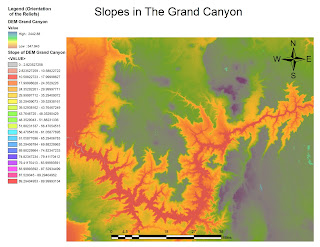
 The Grand Canyon is a worldwide famous attraction. With ArcGis it is possible to create in few steps a model of its topography and extract important data such as slopes, orientation, exact geographical location, and project all these in Thematic Maps starting from Remote Sensing data. As shown below, Digital Elevation models offer a wide range of application, such as Geomorphology and Geological Studies. It is incredibly high the level of precision these models can reach, ranging from 90x90 meters resolution worldwide, 30x30 in the US and Sub metrical resolution for commercial files. This map shows a representation of slopes using a chromatic range, a very common and useful tool of ArcGis applied in several fields of Geography. At the same way surface images from Mars, Venus, the Moon and Mercury have been studied by scientists in order to understand physical processes of their surfaces.
SPECIFIC DATA ABOUT LOCATION
The Grand Canyon DEM's data used for this exercise have been the Elevation Raster Data of the area with this four angles: From 35.64 to 36.61 North and from 113.97 to 112.79 West.
This means that the areas covered occupies approximately 0.97 degrees of LATITUDE and 1.18 of LONGITUDE, having as a result a Rectangular Shape.
The Geographical Reference Systems used is the North American Datum 1983, upon which the elevation data of the DEM are based.
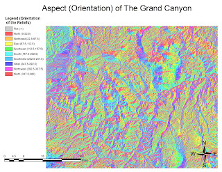
The ASPECT Tool is also very useful, allowing us for example to understand which could have been the role of solar and winds' exposition of rocks into the processes of formation of topographic features, or, in case of Urban Planning and Architectural Studies, studying strategies for augmenting light exposure.
A Map that joins the two characteristics:
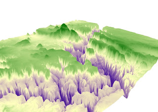
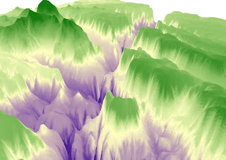
The last ones are some 3D models of the area, creating by adding a Z dimension into a new projection. Several Other tools such as a flyby or virtual guided tours can be created to have different perspectives of surfaces or objects.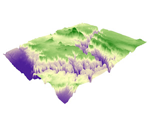
Digital Elevation Models are an important and basiliar tool of GIS, which may be combined with all other thematic databases in order to discover relationships between patterns and probably the most important feature of Earth's surface. The Grand Canyon is a worldwide famous attraction. With ArcGis it is possible to create in few steps a model of its topography and extract important data such as slopes, orientation, exact geographical location, and project all these in Thematic Maps starting from Remote Sensing data. As shown below, Digital Elevation models offer a wide range of application, such as Geomorphology and Geological Studies. It is incredibly high the level of precision these models can reach, ranging from 90x90 meters resolution worldwide, 30x30 in the US and Sub metrical resolution for commercial files. This map shows a representation of slopes using a chromatic range, a very common and useful tool of ArcGis applied in several fields of Geography. At the same way surface images from Mars, Venus, the Moon and Mercury have been studied by scientists in order to understand physical processes of their surfaces.
SPECIFIC DATA ABOUT LOCATION
The Grand Canyon DEM's data used for this exercise have been the Elevation Raster Data of the area with this four angles: From 35.64 to 36.61 North and from 113.97 to 112.79 West.
This means that the areas covered occupies approximately 0.97 degrees of LATITUDE and 1.18 of LONGITUDE, having as a result a Rectangular Shape.
The Geographical Reference Systems used is the North American Datum 1983, upon which the elevation data of the DEM are based.

The ASPECT Tool is also very useful, allowing us for example to understand which could have been the role of solar and winds' exposition of rocks into the processes of formation of topographic features, or, in case of Urban Planning and Architectural Studies, studying strategies for augmenting light exposure.

A Map that joins the two characteristics:

The last ones are some 3D models of the area, creating by adding a Z dimension into a new projection. Several Other tools such as a flyby or virtual guided tours can be created to have different perspectives of surfaces or objects.


No comments:
Post a Comment