


 The above map shows the rainfall as in 25th February 2011 for the current season.
 The second map shows the rainfall of a normal season in Los Angeles County. It is inmediately clear that the third case, the Kriging analysis show a map of precipitation substantially different form the other two. This is because in the normal values have been created with a mean calculation process that didn't allow the record of higher peaks of rain in one single station (which have been recorded in more than one case between the current season records).
| NAME | ID Number | LAT | LONG | Elevation feet | Current S. | Normal S. | Difference S. | Elevation mts. | |
| Acton Camp Precip | 58 | 34.450556 | -118.198333 | 2,625.00 | 6.65 | 10.03 | -3.38 | 800.10 | |
| Agoura Precip | 56 | 34.135556 | -118.751944 | 800 | 13.7 | 17.84 | -4.14 | 243.84 | |
| Aliso Canyon Precip | 57 | 34.328333 | -118.554722 | 2,367.00 | 20.16 | 22.82 | -2.66 | 721.46 | |
| Aliso Canyon Wagon Wheel | 4 | 34.274722 | -118.526389 | 1112 | 17.13 | 19.57 | -2.44 | 338.94 | |
| Avek Precip | 54 | 34.539167 | -117.923056 | 2,825.00 | 6.06 | 5.78 | 0.28 | 861.06 | |
| Ballona Crk Precip | 55 | 33.998611 | -118.401389 | 38 | 8.94 | 12.39 | -3.45 | 11.58 | |
| Bell Canyon (Rocketdyne) Precip | 52 | 34.178056 | -118.590833 | 2,260.00 | 14.02 | 14.74 | -0.72 | 688.85 | |
| Bell Cyn Debris Basin Precip | 53 | 34.194167 | -118.656389 | 895 | 12.28 | 15.57 | -3.29 | 272.80 | |
| Big Pines Recreation Park Pcp | 50 | 34.378889 | -117.688889 | 6,860.00 | 26.73 | 24.5 | 2.23 | 2,090.93 | |
| Big Rock Mesa Precip | 51 | 34.039167 | -118.616667 | 300 | 19.65 | 16.58 | 3.07 | 91.44 | |
| Big Tujunga-camp15 Precip | 46 | 34.289167 | -118.288056 | 1,525.00 | 13.74 | 19.36 | -5.62 | 464.82 | |
| Bouquet Cyn @ Urban Precip | 47 | 34.448333 | -118.505833 | 1,300.00 | 9.88 | 7.98 | 1.9 | 396.24 | |
| Brand Park Precip | 48 | 34.188056 | -118.271944 | 1,250.00 | 14.17 | 18.34 | -4.17 | 381.00 | |
| Brown's Canyon Precip | 49 | 34.311667 | -118.607222 | 2,400.00 | 19.25 | 19.55 | -0.3 | 731.52 | |
| Cedar Springs Precip | 42 | 34.355833 | -117.873333 | 6,780.00 | 30.16 | 29.95 | 0.21 | 2,066.54 | |
| Chilao-St Hwy Precip | 43 | 34.317778 | -118.008056 | 5,275.00 | 20.75 | 22.9 | -2.15 | 1,607.82 | |
| Clear Crk School Precip | 44 | 34.276944 | -118.17 | 3,150.00 | 27.52 | 30.54 | -3.02 | 960.12 | |
| Cogswell Dam Precip | 45 | 34.243333 | -117.963333 | 2,300.00 | 25.47 | 34.21 | -8.74 | 701.04 | |
| Domin Wat Co Precip | 39 | 33.831389 | -118.224722 | 30 | 13.9 | 12.11 | 1.79 | 9.14 | |
| DP WHQ | 1 | 34.081667 | -118.150278 | 466 | 18.5 | 16.82 | 1.68 | 142.04 | |
| Eagle Rock Rsvr Precip | 40 | 34.145556 | -118.19 | 1,085.00 | 16.34 | 18.14 | -1.8 | 330.71 | |
| Eaton Wash Precip | 41 | 34.074722 | -118.054722 | 261 | 16.26 | 12.4 | 3.86 | 79.55 | |
| Flintridge Precip | 38 | 34.181667 | -118.185556 | 1,600.00 | 23.03 | 22.09 | 0.94 | 487.68 | |
| LA 96th & Cen. Precip | 36 | 33.948889 | -118.254444 | 121 | 12.99 | 13.78 | -0.79 | 36.88 | |
| LA Ducommun St Precip | 37 | 34.0525 | -118.236667 | 306 | 13.54 | 15.63 | -2.09 | 93.27 | |
| La Mirada Precip | 28 | 33.883056 | -118.016667 | 75 | 9.33 | 13.45 | -4.12 | 22.86 | |
| La Rvr @ Wardlow Precip | 29 | 33.819722 | -118.122 | 25 | 11.3 | 9.9 | 1.4 | 7.62 | |
| La Tuna DB Precip | 30 | 34.236667 | -118.326667 | 1,160.00 | 12.52 | 16.44 | -3.92 | 353.57 | |
| Lancaster Roper Precip | 31 | 34.679722 | -118.010278 | 2,400.00 | 7.24 | 5.34 | 1.9 | 731.52 | |
| Lancaster Waterworks | 3 | 34.801111 | -118.559722 | 2910 | 7.24 | 5.34 | 1.9 | 886.97 | |
| Le Habra Heights | 11 | 33.960833 | -117.950556 | 755 | 15.98 | 15.85 | 0.13 | 230.12 | |
| Lechuza Pat Sta Precip | 32 | 34.076944 | -118.879444 | 1,620.00 | 21.85 | 22.4 | -0.55 | 493.78 | |
| Lewis Ranch Precip | 33 | 34.42 | -117.886389 | 4,615.00 | 17.17 | 15.21 | 1.96 | 1,406.65 | |
| Little Gleason Precip | 34 | 34.378333 | -118.149167 | 5,600.00 | 15.67 | 23.87 | -8.2 | 1,706.88 | |
| Little Rock Crk Above Dam Percip | 35 | 34.478056 | -118.023333 | 3,267.00 | 9.8 | 9.16 | 0.64 | 995.78 | |
| Loomis Ranch Precip | 27 | 34.348333 | -118.048056 | 4,325.00 | 15.39 | 18.55 | -3.16 | 1,318.26 | |
| Mescal Smith Precip | 24 | 34.4675 | -117.711111 | 3,810.00 | 9.29 | 7.8 | 1.49 | 1,161.29 | |
| Mint Cyn @ Fitch Precip | 25 | 34.446667 | -118.4275 | 1,652.00 | 9.02 | 9.05 | -0.03 | 503.53 | |
| Monte Nido Fire Precip | 26 | 34.077778 | -118.692222 | 600 | 19.65 | 22 | -2.35 | 182.88 | |
| Newhall-Sol Precip | 21 | 34.425833 | -118.578333 | 1,243.00 | 13.74 | 17.89 | -4.15 | 378.87 | |
| North Lancaster Precip | 22 | 34.761389 | -118.125 | 2,310.00 | 2.68 | 5.19 | -2.51 | 704.09 | |
| Northridge- LADPW Precip | 23 | 34.231111 | -118.541111 | 1,117.00 | 12.8 | 15.3 | -2.5 | 340.46 | |
| Pacoima Dam Precip | 20 | 34.33 | -118.399444 | 1,950.00 | 17.2 | 19.54 | -2.34 | 594.36 | |
| Palmdale Water Dist Precip | 17 | 34.594722 | -118.091944 | 2,595.00 | 7.17 | 6.93 | 0.24 | 790.96 | |
| Pine Canyon Patrol Station Pcp | 18 | 34.673333 | -118.429167 | 3,286.00 | 17.24 | 19.14 | -1.9 | 1,001.57 | |
| Pnt Vicen Ligh Precip | 19 | 33.741667 | -118.410556 | 125 | 18.87 | 11.07 | 7.8 | 38.10 | |
| Pudd Div Precip | 15 | 34.129167 | -117.780833 | 1,130.00 | 20.43 | 19.21 | 1.22 | 344.42 | |
| Quartz Hill Precip | 16 | 34.648056 | -118.24 | 2,395.00 | 9.96 | 7.97 | 1.99 | 730.00 | |
| Redman Precip | 14 | 34.764444 | -117.925 | 2,360.00 | 5.59 | 5.18 | 0.41 | 719.33 | |
| Relay | 2 | 34.735 | -117.776944 | 3057 | 6.52 | 5.15 | 1.37 | 931.77 | |
| Rocky Buttes Precip | 13 | 34.65 | -117.863333 | 2,540.00 | 6.57 | 4.84 | 1.73 | 774.19 | |
| San Gab Pow House Precip | 12 | 34.155556 | -117.907778 | 744 | 16.16 | 22.98 | -6.82 | 226.77 | |
| San Gabriel Dam Precip | 7 | 34.205556 | -117.860556 | 1,481.00 | 28.78 | 28.86 | -0.08 | 451.41 | |
| San Gabriel East Fork Percip | 8 | 34.235833 | -117.805 | 1,600.00 | 25.55 | 26.04 | -0.49 | 487.68 | |
| Sanberg Airways Station Precip | 9 | 34.746389 | -118.724167 | 3,635.00 | 10.94 | 12.85 | -1.91 | 1,107.95 | |
| Santa Anita Dam Precip | 10 | 34.184167 | -118.019722 | 1,400.00 | 27.17 | 26.21 | 0.96 | 426.72 | |
| Tanbark Precip | 6 | 34.205278 | -117.760833 | 2,750.00 | 43.66 | 28.04 | 15.62 | 838.20 | |
| Topanga Canyon Patrol Station Pcp | 5 | 34.084167 | -118.599167 | 745 | 18.89 | 24.42 | -5.53 | 227.08 |
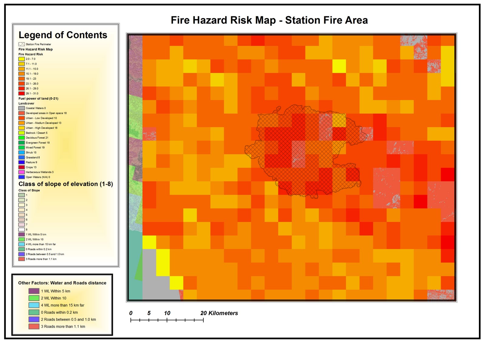 FINAL MAP: FIRE HAZARD RISK AND STATION FIRE EXTENT.

 MAP 3:

Dear LA City Council, I would like to express my agreement with the idea about the institution of the 1,000 feet buffer law from the marijuana dispensers.
I thought the idea was very unlikely to be realized because of the limites space in the urban tissue, but considering four kinds of locations:
- Schools;
- Churches;
- Recreation areas;
- Public Libraries;
- Public Parks;
Only 3 of these public facilities and institutions resulted within the 500 feet boundaries,
While more than 22 of these resulted in the requested 1,000 feet buffer, as you can see in the selection.
The reason is that I think as a Geographer that such an objective is practically impossible to realize. The buffers of all the locations involved, such as public libraries, schools, recreation centers.
I would rather suggest to transform the buffer into a 500 feet buffer zone from all those five locations. In this way the changes for retailers should be acceptable, rather than changing locations for all the 5 typologies of locations and the retailers/dispensers themselves


